
Dangerous Haze Blankets Kalimantan as PM2.5 Reaches Extreme Levels in Three Cities
Air quality in Palangka Raya, Pangkalan Bun, and Sintang reached hazardous levels on Wednesday as forest and peatland fires continue to produce toxic smoke across Kalimantan, part of Indonesia's worst wildfire season in over a decade.

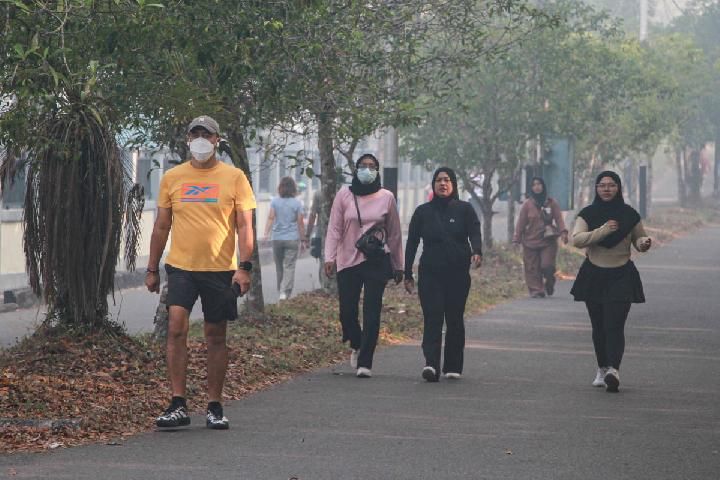
Kalimantan Haze: Air Quality Hits Hazardous Level in 3 Regions
Three cities across Kalimantan plunged into hazardous air quality conditions on Wednesday, October 14, 2026, as concentrations of fine particulate matter from forest and peatland fires reached levels dangerous to human health. By Thursday morning, pollution remained in the very unhealthy range across multiple regions.
Monitoring data from the Meteorology, Climatology, and Geophysics Agency (BMKG) showed PM2.5 concentrations exceeding 250.5 micrograms per cubic meter—the threshold for hazardous air—in Palangka Raya, Pangkalan Bun, and Sintang on Wednesday afternoon. Palangka Raya recorded the nation's highest reading at 3,340 μg/m3 at 1:00 p.m. WIB, a sharp increase from 2,512 μg/m3 measured one hour earlier. Pangkalan Bun followed with 378.8 μg/m3, while Sintang registered 307.2 μg/m3.
The extraordinarily high particulate concentrations stem from the nature of peatland fires, which produce approximately three times more fine particulate matter than surface fires. These fires smolder underground through deep organic deposits, making them harder to detect and extinguish even during light rainfall.
By Thursday morning at 10:00 a.m., Pontianak's Air Quality Index stood at 266 (Very Unhealthy) with PM2.5 levels at 191 μg/m3. Palangka Raya registered an AQI of 217 with PM2.5 at 141.9 μg/m3. Sintang recorded 227 AQI at 9:00 a.m. local time with 152.1 μg/m3 PM2.5. Mempawah showed 207 AQI with 131.9 μg/m3 PM2.5, while Pangkalan Bun had improved slightly to the unhealthy red band with an AQI of 164 and PM2.5 at 74.2 μg/m3.
Indonesia's Worst Fire Season in 11 Years
The current crisis represents Indonesia's most intense wildfire season in 11 years, driven by a combination of degraded peatlands and extreme weather conditions. By August 2026, approximately 202,000 hectares of forests and land had burned across Indonesia according to the Minister of Forestry, marking a 110 percent increase compared with the same period in 2023 when El Niño last affected the country.
A super El Niño climate phenomenon combined with a positive Indian Ocean Dipole has contributed to a prolonged dry season from April to October 2026. Some regions have experienced drought conditions reaching 131 consecutive days without rain, creating ideal conditions for fires to ignite and spread.
Of Indonesia's estimated 24.2 million hectares of peatland, 16.4 million hectares have been degraded and are vulnerable to fire, primarily due to development of industrial-scale plantations for timber, pulp, paper, rice, and palm oil. Kalimantan provinces accounted for 72 percent of all deforestation for palm oil in Indonesia during 2018-2022, with industrial plantation expansion and land clearing identified as major factors contributing to fire vulnerability in the region.
Widespread Health Impact
More than 12.5 million people across seven Indonesian provinces have been exposed to haze from the 2026 fires, with respiratory infections linked to fires rising to 113,336 cases as of September 9, 2026. Between September 1 and September 7, Indonesia released 19.7 million metric tons of fire emissions, the highest of any country in the world that week and more than a third of the global total.
Short-term exposure to PM2.5 levels above hazardous thresholds has been associated with premature mortality, increased hospital admissions for heart or lung causes, acute bronchitis, asthma attacks, and respiratory symptoms, particularly affecting infants, children, and older adults with preexisting conditions.
National Disaster Management Agency (BNPB) data indicated 3,835 hotspots and 49 active fires in Central Kalimantan as of Tuesday, October 13, reducing visibility in parts of the region to 200 meters. West Kalimantan recorded 466 hotspots and 10 active fires, with visibility ranging between 200 meters and 7 kilometers. Both provinces are among six priority areas targeted for forest fire suppression efforts.
Forecast and Precautions
Hourly forecasts indicate air pollution in Pontianak will remain very unhealthy through midday Thursday before shifting to the unhealthy band around 4:00 p.m., with an AQI of 195. In Palangkaraya, pollution is expected to remain elevated throughout the day, with readings forecast to reach 261 early Friday morning.
Health officials are urging residents in affected areas, particularly children, the elderly, pregnant women, and individuals with respiratory conditions, to limit outdoor activity and use protective masks when outside.