
South Papua Fires Threaten Wasur National Park's Bird Habitats
Forest and land fires in South Papua are threatening Wasur National Park, a refuge in Merauke Regency for 403 bird species and thousands of migrating waterbirds. Officials warn that conservation areas remain at risk even as the province's reported fire figures declined between October 31 and November 1, 2026.

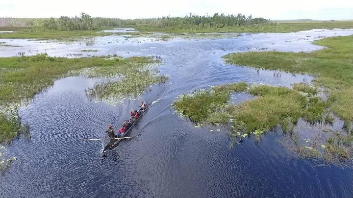
Wetlands, wildlife and a city water source
Wasur encompasses about 431,425 hectares of savanna, swamps and forests, managed by the Ministry of Forestry's Directorate General of Natural Resources and Ecosystem Conservation (KSDAE). The park office's records include 74 bird species endemic to Papua and 114 protected species. Waterbirds arriving from Australia and New Zealand use the park to rest and feed during migration.
Fires have already affected a substantial area of Wasur this year. Figures compiled from accounts of fires across Indonesia, reported by Asia Daily, put the park's burned area at about 8,708 hectares from January through August 2026—the largest among the country's national parks during that period.
The park also contains Rawa Biru village and Lake Rawa Biru. Ministry of Forestry information identifies the lake as a source of water that the Merauke regional government distributes through the local PDAM utility to meet Merauke city residents' daily clean-water needs.
Merauke accounts for most of the fire area
National Disaster Management Agency (BNPB) figures cited by Detik put South Papua's burned area at 695 hectares as of 5:00 p.m. WIB on November 1, with 253 hectares still unextinguished. Monitoring teams recorded 379 hotspots and 171 active fires. The previous day's figures were 1,742 hectares burned and 577 hectares unextinguished.
Most of the province's fire activity was concentrated in Merauke. In a November 1 press release, BNPB head Kristomei Sianturi said analysis of Sentinel-2 and MODIS satellite imagery attributed 90 percent of South Papua's hotspots, 96 percent of its burned area and 97 percent of its unextinguished fire area to the regency.
BNPB designated the Jago Merah-Tanah Miring cluster as a priority for the response. The cluster, which includes Jago Merah, Tanah Miring, Animha and Semangga, contained about 250 of the 502 hectares still burning across South Papua on October 29. It accounted for 36 percent of the province's hotspots on October 30.
An earlier warning came from WALHI Papua executive director Maikel Primus Peuki. Speaking at an October 13 discussion, he reported a surge in forest and land fires, with 573 hotspots detected in South Papua. His account drew on the group's monitoring and statements from the Jayapura Region V office of the Meteorology, Climatology, and Geophysics Agency (BMKG).
Habitat damage can outlast the flames
The threat to wildlife goes beyond the loss of trees. Detik reported that burning vegetation and wetland cover removes places where animals forage, nest and breed. Smoke and changes in soil conditions also disturb species whose geographic ranges are limited.
University of Papua researchers Damianus V.S. Woghomugu and Hermanus Warmetan describe Wasur's forest types and wetlands as interconnected in their study. Its biodiversity depends on those connections, so damage to one part of the habitat can impair ecological functions elsewhere in the park.
Research elsewhere in South Papua also documents the vulnerability of wildlife to habitat loss. A study published in November 2025 in IPB University's Journal of Conservation Media examined disturbed forests and found significant declines in reptile and amphibian diversity and population numbers where habitat degradation was high.
A separate 16-year study of Indonesian tropical peat forests illustrates the difficulties of recovery. Published in April 2024 in the Proceedings of the National Academy of Sciences (PNAS), it found declines of 58 to 98 percent in canopy cover and tree density in burned forests. Some ecological indicators improved over a 12-year period, but the researchers warned that repeated fires could permanently impede natural regeneration.
Emergency agencies say both fire containment and restoration of damaged habitats are needed to protect Papua's biodiversity and the international migratory bird corridor.
Monitoring, ground crews and cloud seeding
BNPB and BMKG have expanded their use of satellites and drones to monitor the fires. On the ground, Regional Disaster Management Agency (BPBD) personnel are working alongside the Indonesian National Armed Forces (TNI), the Indonesian National Police (Polri) and Manggala Agni firefighting units.
BNPB Chief Lt. Gen. Kristomei Sianturi and BMKG Chief Teuku Faisal also surveyed Merauke Regency from the air to examine conditions directly.
"Response efforts are being strengthened through satellite and drone-based monitoring, hotspot verification, and coordination with BPBD, local governments, TNI, Polri, Manggala Agni, and related agencies to expedite the response at the fire site," said Berton SP Panjaitan, head of BNPB's National Disaster Data, Information, and Communication Center, as reported by CNN Indonesia.
The government has also extended Weather Modification Operations (OMC), intended to induce rainfall, through November 5, 2026. The initial phase began October 22; by October 31, aircraft had flown 13 cloud-seeding sorties and dispersed 13,000 kilograms of sodium chloride over targeted areas.