
Indonesia rushes over 100 tons of aid to earthquake-stricken East Nusa Tenggara
Indonesia's disaster agency deployed military aircraft and naval vessels to deliver emergency supplies following a magnitude 7.7 earthquake that struck East Nusa Tenggara on August 15, triggering tsunami warnings and displacing thousands across the archipelago province.
Indonesia rushes over 100 tons of aid to earthquake-stricken East Nusa Tenggara
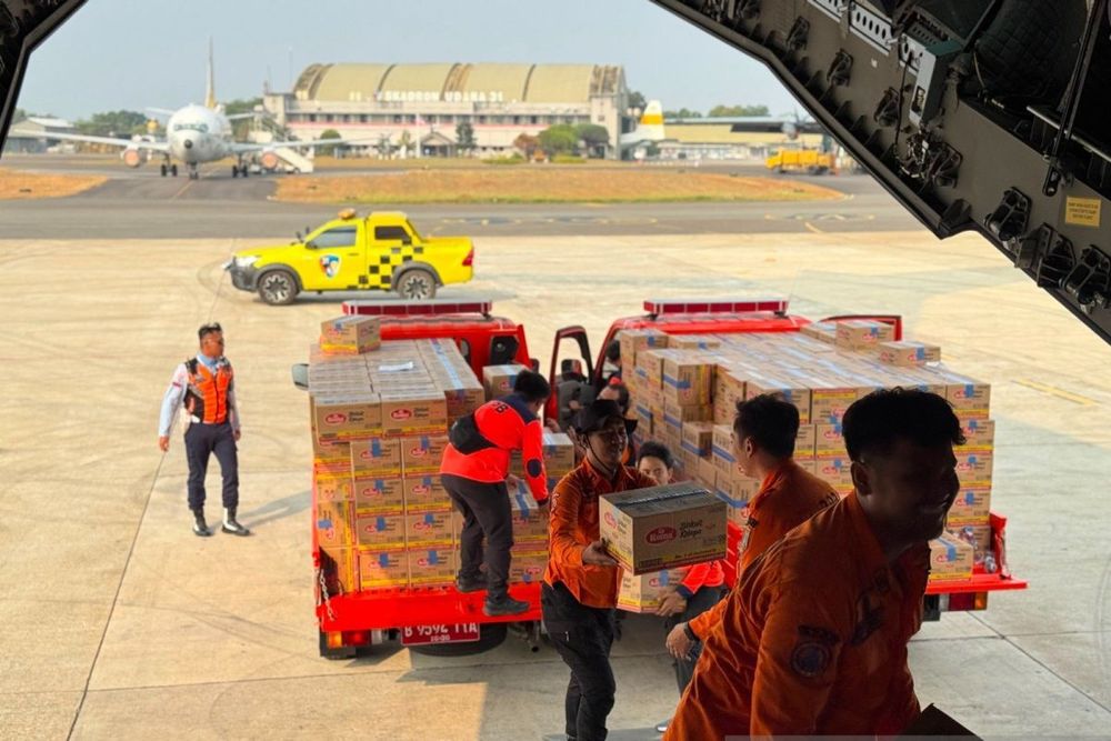
Indonesia's National Disaster Mitigation Agency (BNPB) has launched an intensive relief operation to East Nusa Tenggara following a devastating magnitude 7.7 earthquake that struck at 5:58 AM local time on August 15, 2026, delivering over 100 tons of emergency supplies via military airlifts and sea routes.
The earthquake's epicenter was located approximately 68 kilometers north-northwest of Ende city at a depth of 10 kilometers. The tremor triggered tsunami warnings across four Indonesian provinces, with small waves detected at 0.36 meters in Labuan Bajo, 0.19 meters in Sikka, and 0.17 meters in Dompu. More than 230 aftershocks followed throughout the day, the strongest measuring magnitude 6.2, compounding the challenge facing relief operations.
Berton Panjaitan, BNPB's acting head of data and communications, confirmed Monday that continuous air operations from Jakarta's Halim Perdanakusuma Air Base have been underway since Saturday to reach affected communities across the province, which comprises more than 500 islands with a population of approximately 5.6 million people.
On Monday alone, the Indonesian Air Force flew three C-130 Hercules transport sorties to Labuan Bajo and Maumere, delivering over 40.5 metric tons of aid. The C-130 Hercules, capable of carrying up to 20.4 metric tons per flight and specifically designed to operate from rough, unpaved runways, proved critical for reaching areas with damaged infrastructure.
The shipments included thousands of family food packs, canned protein reserves, essential medicines, and two heavy-duty field hospital tents. Between August 15 and 17, BNPB recorded seven military cargo flights delivering a combined 101.5 metric tons of emergency supplies to regional distribution hubs across the province.
Access Challenges to Epicenter Region
Landslides blocked roads and disrupted communications to Nagekeo regency, the area closest to the earthquake's epicenter, forcing rescue teams to attempt access by ferry. The difficult terrain and infrastructure damage have made the multi-modal transportation approach essential for ensuring isolated disaster zones receive immediate support.
The East Nusa Tenggara provincial government declared a 14-day emergency response period running from August 15 to 28, 2026, providing the legal framework for coordinated relief efforts. BNPB, established in 2008 following Law No. 24 of 2007 on Disaster Management and reporting directly to the President of Indonesia, is coordinating joint operations involving the Indonesian Military (TNI), government ministries, and non-governmental humanitarian partners.
Recurring Seismic Threat
The affected region has experienced similar disasters before. The same stretch of coastline in Flores was struck by a powerful earthquake in December 1992 that, along with the tsunami it triggered, killed more than 2,500 people. Indonesia's location on the Pacific Ring of Fire, a seismically active belt where tectonic plates converge, makes the archipelago nation particularly vulnerable to frequent earthquakes and volcanic eruptions.
East Nusa Tenggara remains one of Indonesia's least developed provinces, with most residents relying on subsistence farming. This economic vulnerability has intensified concerns about the affected population's capacity to recover from the disaster.
Panjaitan emphasized that coordination efforts continue to ensure logistics and air transport support can be delivered quickly according to the needs of communities in the affected areas, as surface and maritime deliveries expand to supplement the ongoing airlift operations.